Search

Travelling Photographer

Photos and commentary from my travels around the globe

Category

Route 66

Route 66 – Oklahoma City to Miami OK – my last day on the Mother Road

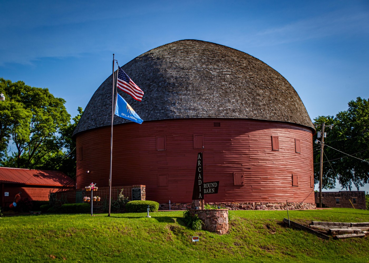
With an early morning start I motored out of OKC and headed to Arcadia OK to see Pops Arcadia (a landmark diner & gas station with hundreds of sodas, a shop & a 66-ft.-tall soda bottle out front) and the Arcadia Round Barn (It was built by local farmer William Harrison Odor in 1898 using native bur oak boards soaked while green and forced into the curves needed for the walls and roof rafters).

Continuing on to Chandler OK to see – Seaba Filing Station — now a motorcycle museum, the Museum of Pioneer History, Lincoln Motel and Chandler Philips Station.

In Stroud OK we have the Skyliner Motel sign – the motel is still in business but a little iffy.IMG_0954

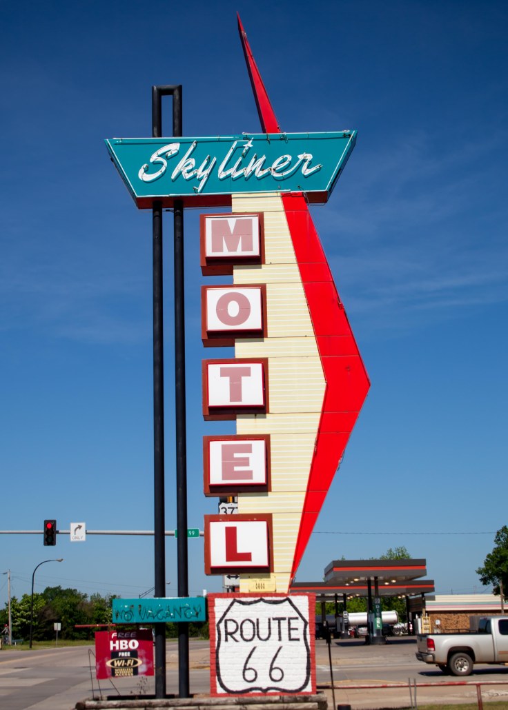
It was like travelling  back to the 1890s, when Bristow OK originated near a railroad track between Sapulpa and Oklahoma City. At the recently restored Bristow Historical Depot and Town Square, I saw how the small town functioned back when cotton was king and the railroad was the main event. Gene Autry,  once served as a telegrapher in this  depot, formerly known as the Frisco Railway depot. Too bad the Trump organization is in such a decline here!

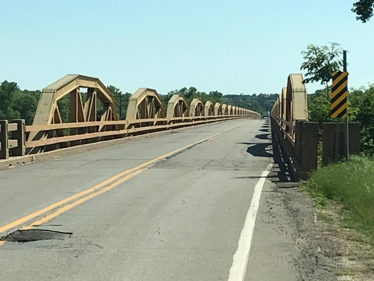
In Sapulpa OK I was able to drive over the Rock Creek Bridge. Of the great number of bridges built on Route 66, Bridge #18 at Rock Creek is one of the better examples of the remaining steel-truss bridges in Oklahoma. Truss bridges were developed in the mid-1800s and used extensively until World War II, when technology changed and more standardized concrete designs were developed. Right around the bend from the bridge is the Worlds Largest Gas Pump.

The Highlights of Tulsa OK – Route 66 Village, Route 66 Numbers 1,2,3, Meadow Gold Sign and The Blue Dome.

In Catoosa OK –The Blue WhaleIMG_0999

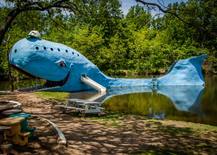
For one of the strangest attractions on the trip I diverted from 66 to Chelsea OK and The Ed Galloway Totem Pole Park.IMG_4637

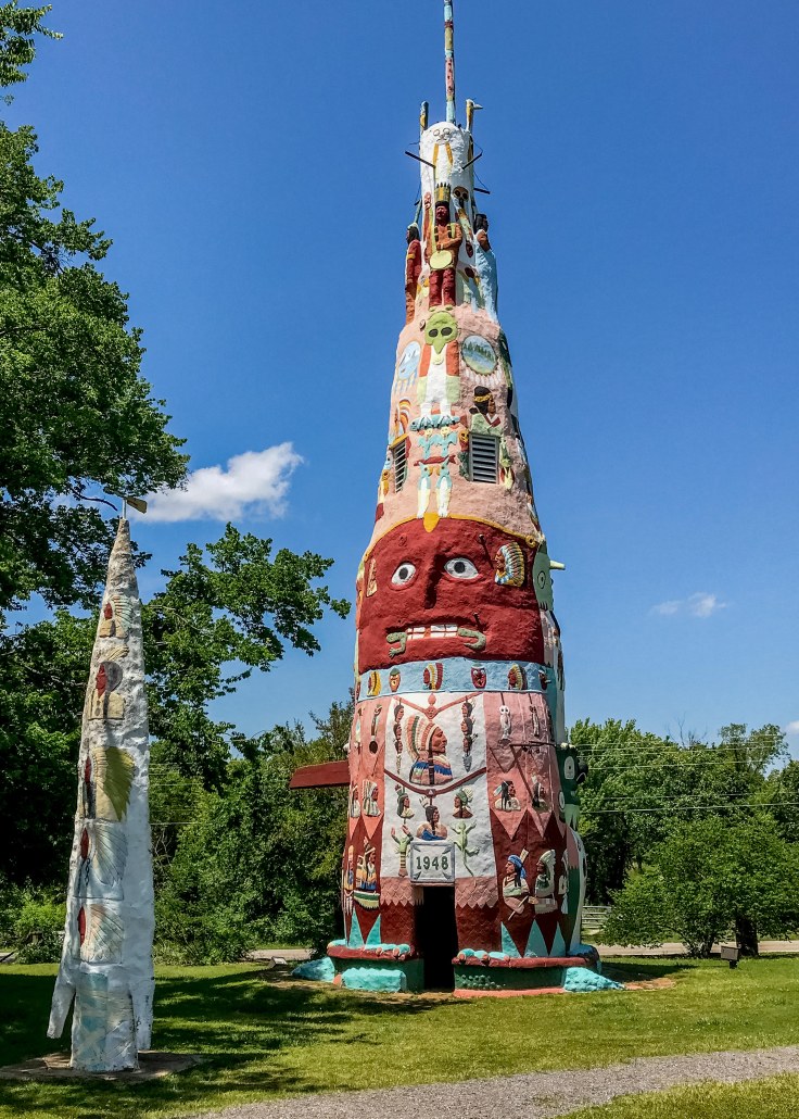
An finally, Miami OK and my last stop on the Mother Road – at least for this trip. The Gateway Sign and the Coleman Theater (The theater is a historic performance venue and movie house. Built in 1929 for George Coleman, a local mining magnate, it has a distinctive Mission Revival exterior, and an elaborate Louis XV interior – too bad it was closed and I could not view the interior).

On to Arkansas for the night – hopefully mid Tennessee Friday and Raleigh Saturday.


Route 66 – Tucumcari NM to Oklahoma City

Early start today – needing to put on some miles to make Raleigh on Saturday. After a disappointing yesterday today there were many stops and great photo ops. One of the concerns along the way are the many historic buildings that are no longer around since my research dating back 4 years. First stop of the day was the Russells Travel Center in Glenrio NM – not your typical center – it contains some great sculptures and a fantastic car and car memorabilia museum.

Adrian TX has the honor of being the Geo-mathematical Center of Route 66: the original U.S. highway 66 ran 1,139 miles east to Chicago and the same distance west to Los Angeles. This small rural town is the midpoint and halfway point of US Route 66. IMG_0833


Next stop Amarillo TX and two of my favorites from previous trips. Cadillac Ranch  a public art installation and sculpture garden (well its in a farmers field). It was created in 1974 by Chip Lord, Hudson Marquez and Doug Michels, who were a part of the art group Ant Farm.  Visitors are welcome to paint the cars as they wish and today there were several “artists” adding additional layers to the cars. Then on to the Big Texan – a kitschy, saloon-style steakhouse offering patrons a 72-oz. steak challenge (eat it with sides in an hour and its free if not you pay $72.00).

Trump Tower Groom TX.IMG_4560

Two stops in McLean TX. – A historic Phillips 66 service station and a great museum “Devils Rope”  – history of barbed wire. No they couldn’t tell me how many miles of wire has been used across the USA. BTW it also has a great Rt.66 exhibit. I can’t believe that this museum survives in a town that is in worse shape then some of the ghost towns I passed out west.

Shamrock TX  –The U-Drop Inn, also known as Tower Station and U-Drop Inn and Tower Café, was built in 1936 in Shamrock, Texas along the historic Route 66 highway. Inspired by the image of a nail stuck in soil, the building was designed by J. C. Berry.


Erick OK. – Sand Hills Curiosity ShopIMG_0892

Hydro OK. – Lucille’s Service Station, a classic and historic gas station along Route 66 near Hydro, is one of only two upper-story, out-thrust porch style stations left on Oklahoma’s stretch of Route 66. Built in 1929 by Carl Ditmore, the service station was renamed by Provine Station in the 1930s. In 1941, the Hamons family took over the operation of the station and Lucille Hamons, for which the service station is named, ran the business for 60 years. Lucille, who quickly became known for her friendly assistance to motorists, earned the nickname “Mother of the Mother Road.” IMG_0907

Geary OK – Pony Bridge -Its official name is the William H. Murray Bridge, but this distinct bridge spanning the South Canadian River has long been known as Pony Bridge because it is built using pony trusses, which are bridge trusses that don’t connect at the top. At 3,944 feet with 38 trusses, it’s the longest bridge on Oklahoma’s stretch of Route 66. It made a brief appearance during the 1939 film “The Grapes of Wrath.” Wish I had a drone – impossible to get a view from the ground.IMG_4583

Oklahoma City OK -The Milk Bottle Grocery is a grocery building with a large metal milk bottle atop its roof. The store was constructed in 1930, and the milk bottle was added in 1948.  IMG_0920

Wednesday will be my last day on Route 66 – it will be an adventure – some of the towns along the way have recently experienced tornadoes, flooding and road collapse – we shall see what we shall see – then on to Arkansas, Tennessee and North Carolina with hope of reaching Raleigh Saturday morning.

Route 66 – Gallup NM to Tucumcari NM

Today’s drive was a little frustrating – The Mother Road was divided into many short segments requiring slow speeds because of surface problems and with limited photo opportunities. Then when transferring back to I-40 there were considerable construction delays. With all that I did manage to almost traverse the state. Probably the highlight of the day was staying in Tucumcari a town which has tried to hold on to its route 66 past by revitalizing iconic service stations and maintaining its neon lights.

Gallup NM

Continental Divide – found it strange it strange that 66 highlights it by an Indian store.

IMG_0763

Albuquerque NM

East Albuquerque

Santa Rosa NM

Tucumcari NM during the day

Tucumcari NM — at night (need to hone my night photography skills)

Route 66 – Kingman AZ to Gallup NM

You know your out west when you travel through Twin Arrows then Two Guns.IMG_0632

I sped by the exit for the Meteor Crater Natural Landmark (a brown sign looking like a national monument) but a private ripoff that I got suckered into on a previous trip.

My first real stop pf the day was “Standing on the Corner” yup Winslow AZ. I enjoy this stop not only because the town knew a good thing when it saw by capitalizing on the Eagles and “Take it East” (playing loudly from the gift shop across the street) with a mural of the “girl in the flatbed ford” and a statue of a man with his guitar.  Since my last trip a bronze state of Glen Fry was added.

The other highlight of the town is the La Posada Hotel – the first Harvey House – built in the adobe style and as is the case right on the tracks for Amtrak and the SFBN (formerly the Atchison, Topeka, and Santa Fe Railroad). The building and the gardens have been superbly restored and the art work and displays make it a great break on the drive. (http://tinyurl.com/y3ltfmlq)IMG_4498

While touring the building I found several rooms showing works of my new favorite artist – Tina Moin (http://tinyurl.com/y5vbs9j2) – they  speak for themselves.

While bumping along 66 (the road from Winslow when not on I-40 reminds you of a washboard) I found another Wigwam Motel in Holbrook my jumping off point to visit Petrified Forest National Park.

IMG_4519

Not my first visit to the Petrified Forest but I enjoy the 28 mile park road which includes the Painted Desert section with it turnout viewpoints and several short trails thru the “forest”. The trees were fallen and buried in layers of sediment and the logs soaked up ground water and silica from volcanic ash and over time crystallized into quartz.

Petrified Forest


Painted Desert

On to Gallup and a new experience for me – I finally “dined” at a Cracker Barrel (I said I would never do it but a need for shut eye dove me there since it was right next to my hotel). Southern Fried Chicken was fine but the rest blah – what no wine – they were throwing me out at 9:00 – I guess I’m still not a senior citizen – yet.

Route 66 – Kingman to Flagstaff

Arrived late on the 11th in Kingman and after settling in I had dinner @ Dumbar & Steakhouse (recommended by a friend – great steak) then drove around looking for some of the towns neon signs. On the 12th I toured the the town and headed on the longest un-interrupted stretch of 66 in the southwest (Kingman to Seligman).

My first stop was Hackberrry general store. This store in the middle of no where has almost anything Route 66 related. Outside it has historic signage, antique cars and old gas pumps.

Seligman originally started as a railroad town and headed to decay when I-40 was opened. Seligman is now internationally known as an iconic Route 66 town. In 1987, Seligman gained its name “Birthplace of Historic Route 66” due to the efforts of Seligman residents, most notably Angel Delgadillo, the Seligman barber who convinced the State of Arizona to dedicate Route 66 a historic highway. This grassroots effort to bring Route 66 back not only revitalized Seligman but it also caused world-wide interest in Route 66 and the old-fashioned Americana that it represents. (http://tinyurl.com/yyc3373c)

Continuing on to Williams the gateway to the Grand Canyon I walked the town and stopped off at the – Historic Brewing Barrel + Bottle House.

With several hours of daylight left I decided to head north of Flagstaff to Wupatki National Monument and Sunset Crater (http://tinyurl.com/y9fvdwr8). The monument houses several pueblo settlements on a 31 mile loop road. Each of the pueblos are short hikes from the parking areas and allow the exploring of both in and outside of the remains of buildings that are over  800 years old. I explored Lomaki, Naiakihu, Citadel, Wupatki and Wukoki pueblos.

At the end of the loop you get to visit view sites for Sunset Crater, Painted Desert, Cinder hills and Bonito lava flow.

Unfortunately because of road washouts and substantial wash-boarding my trip to Grand Falls has to be scrapped. Not going to risk damage to the several framed paintings and photos that I’m carrying. Here is what I will miss. http://tinyurl.com/yyevh442

Route 66 – The real start

Left Saturday the 11th heading from Pasadena to Kingman AZ. My first stop was in Rancho Cucamonga Ca. to see the restored Richfield Service station and the Sycamore Inn which was founded in 1848.

Continuing up I-15 / Rt 66 to the Cajon Pass (elv 3776) to the site of the old Summit Inn. The Summit Inn was a historic U.S. Route 66 roadside diner built in 1952, located at the summit of Cajon Pass in San Bernardino CountyCalifornia. The building was destroyed by the Blue Cut Fire on August 16, 2016. IMG_0385

Then on to Victorville to see the California Route 66 Museum and lunch at Emma Jean’s Holland Burger.

Did pass on Peggy Sue’s for lunch – been there done that.

IMG_4456

Off to Barstow and a stop at Casa del Desierto — a Harvey House. But along the way a tour of the Bottle Tree Ranch in Oro Grand Ca.

An unplanned side trip to a ghost town (well not so much). Calico was a silver mining town in the late 1880’s. The original town does not have much remaining – but Walter Knott (of Knott’s Berry Farm fame) donated Calico the San Bernardino County which turned it into a regional park and money making operation.


A couple of stops before arriving in Kingman AZ for the night was in Goffs,  Newberry Springs and Needles. Newberry Springs is home to the Bagdad cafe which played a major role in a movie of the same name. Goffs in a town in decline which has the well preserved 1914 school house which is now a museum. The town was also the base for the army desert training center in 1941 and 42.


Rt 66 Continued and a Tour of Rancho Santa Ana Botanical Garden — a fun Easter Drive

For the first time in many years it was just us on Easter. Church and out to breakfast then tracking Rt 66 from Los Angeles to San Bernardino Ca. and home for a surf and turf dinner.

The goal has been to lay the West Coast Rt 66 groundwork before my east coast trip along Rt 66 to Oklahoma then heading to NC and on to Fl. Looking to leave on 5-11-2019 to meet up with my college buds for a week in Nags Head NC then home to Ormond Beach FL.

Todays trip started on Old 66 from South Pasadena along Fair Oaks Ave to Huntington Drive then to downtown LA to the original end of the Mother Road @ 7th Street. We then headed back to Pasadena to see the Colorado Blvd Bridge through Pasadena to The Howard Motor Co building (opened 1929). Then to Monrovia to see the Aztec Motel (opened in 1924), to Arcadia and Rods Grill (new grill opened in 1957), then to  Azusa Foothill Drive-In Theatre, opened on December 18, 1961.

We cruised by several signs for original Rt 66 locations along Foothill Blvd. and then on to the Rancho Santa Ana Botanical Garden in Claremont for a driving brake. Great stop – an hour and a half stroll through several native Southern CA gardens.

Then on to San Bernardino to see the Wigwam Motel and The Original McDonalds location and Museum.

Back to Pasadena for Lobster and Rib Eye.

Great Day

Route 66 LA to San Bernardino


Rancho Santa Ana Botanical Garden


Then Home

Image result for lobster tail pics


Route 66 – Early Start

Planning to head back to Florida in mid-May by car again. As you know we eschew the interstates and head out on the red and blue roads. This time I’m looking into following route 66 — also known as the Will Rogers Highway, the Main Street of America or the Mother Road. Last weekend I started the trip by heading west from Los Angeles on Sunset Blvd. and Santa Monica Blvd. to the “End of the Trail” sign on the Santa Monica Pier. The road trip took me through Beverly Hills and a walk along the bluffs of Santa Monica looking down at the Pier. Looking forward to tripping from Los Angeles to San Bernadino before we leave for real.

Beverly Hills


Santa Monica

Blog at WordPress.com.

Up ↑