Search

Travelling Photographer

Photos and commentary from my travels around the globe

Route 66 – Kingman AZ to Gallup NM

You know your out west when you travel through Twin Arrows then Two Guns.IMG_0632

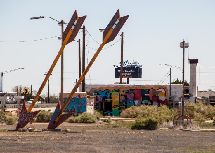
I sped by the exit for the Meteor Crater Natural Landmark (a brown sign looking like a national monument) but a private ripoff that I got suckered into on a previous trip.

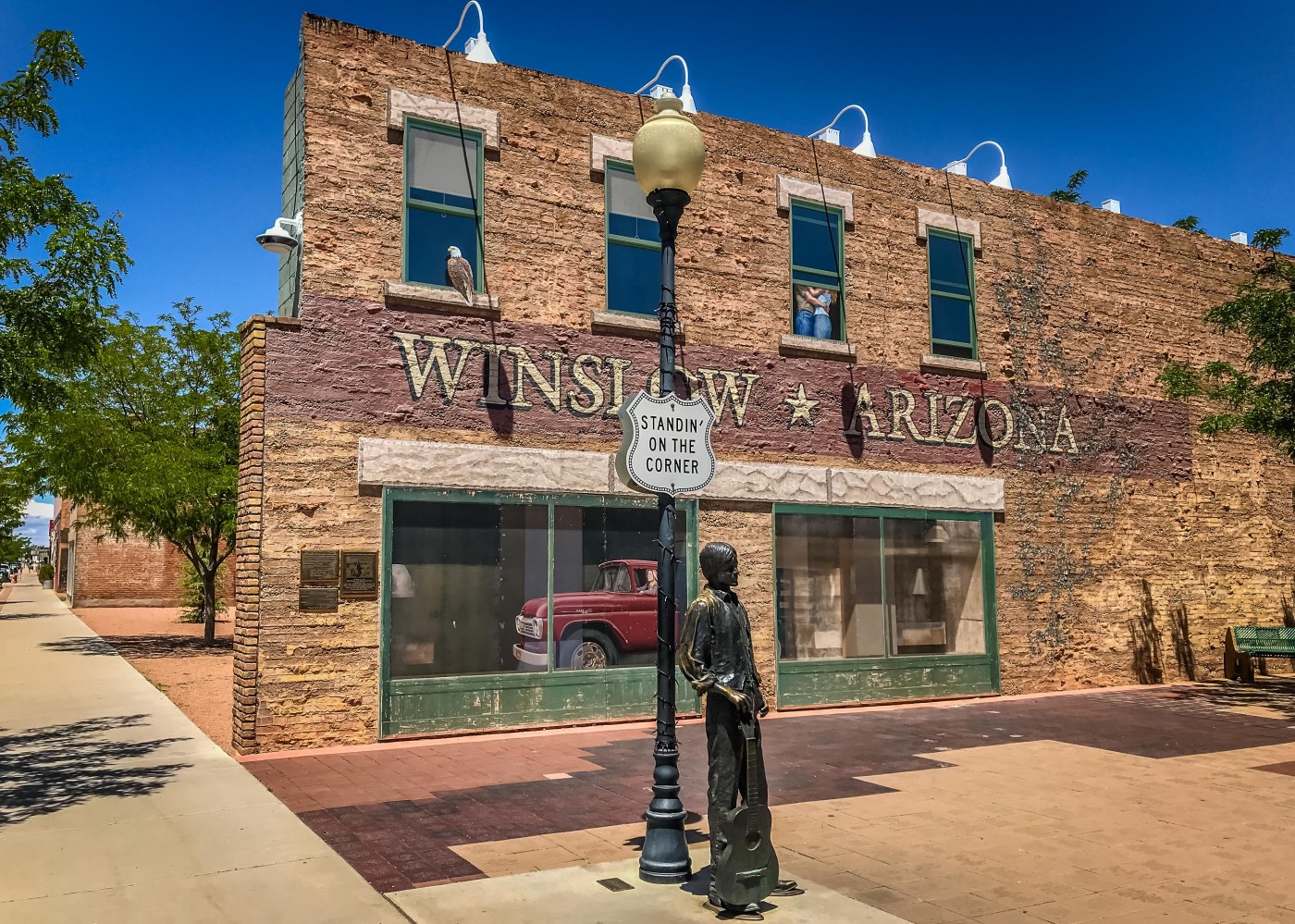
My first real stop pf the day was “Standing on the Corner” yup Winslow AZ. I enjoy this stop not only because the town knew a good thing when it saw by capitalizing on the Eagles and “Take it East” (playing loudly from the gift shop across the street) with a mural of the “girl in the flatbed ford” and a statue of a man with his guitar.  Since my last trip a bronze state of Glen Fry was added.

The other highlight of the town is the La Posada Hotel – the first Harvey House – built in the adobe style and as is the case right on the tracks for Amtrak and the SFBN (formerly the Atchison, Topeka, and Santa Fe Railroad). The building and the gardens have been superbly restored and the art work and displays make it a great break on the drive. (http://tinyurl.com/y3ltfmlq)IMG_4498

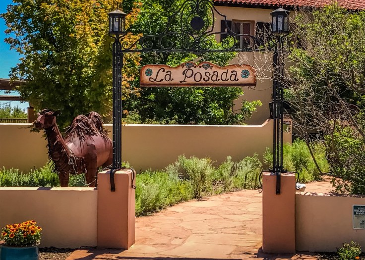
While touring the building I found several rooms showing works of my new favorite artist – Tina Moin (http://tinyurl.com/y5vbs9j2) – they  speak for themselves.

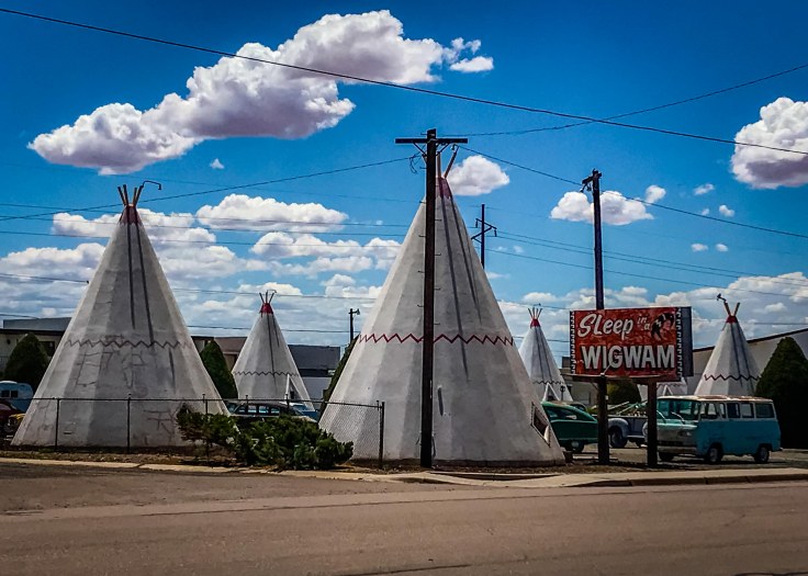
While bumping along 66 (the road from Winslow when not on I-40 reminds you of a washboard) I found another Wigwam Motel in Holbrook my jumping off point to visit Petrified Forest National Park.

IMG_4519

Not my first visit to the Petrified Forest but I enjoy the 28 mile park road which includes the Painted Desert section with it turnout viewpoints and several short trails thru the “forest”. The trees were fallen and buried in layers of sediment and the logs soaked up ground water and silica from volcanic ash and over time crystallized into quartz.

Petrified Forest


Painted Desert

On to Gallup and a new experience for me – I finally “dined” at a Cracker Barrel (I said I would never do it but a need for shut eye dove me there since it was right next to my hotel). Southern Fried Chicken was fine but the rest blah – what no wine – they were throwing me out at 9:00 – I guess I’m still not a senior citizen – yet.

Route 66 – Kingman to Flagstaff

Arrived late on the 11th in Kingman and after settling in I had dinner @ Dumbar & Steakhouse (recommended by a friend – great steak) then drove around looking for some of the towns neon signs. On the 12th I toured the the town and headed on the longest un-interrupted stretch of 66 in the southwest (Kingman to Seligman).

My first stop was Hackberrry general store. This store in the middle of no where has almost anything Route 66 related. Outside it has historic signage, antique cars and old gas pumps.

Seligman originally started as a railroad town and headed to decay when I-40 was opened. Seligman is now internationally known as an iconic Route 66 town. In 1987, Seligman gained its name “Birthplace of Historic Route 66” due to the efforts of Seligman residents, most notably Angel Delgadillo, the Seligman barber who convinced the State of Arizona to dedicate Route 66 a historic highway. This grassroots effort to bring Route 66 back not only revitalized Seligman but it also caused world-wide interest in Route 66 and the old-fashioned Americana that it represents. (http://tinyurl.com/yyc3373c)

Continuing on to Williams the gateway to the Grand Canyon I walked the town and stopped off at the – Historic Brewing Barrel + Bottle House.

With several hours of daylight left I decided to head north of Flagstaff to Wupatki National Monument and Sunset Crater (http://tinyurl.com/y9fvdwr8). The monument houses several pueblo settlements on a 31 mile loop road. Each of the pueblos are short hikes from the parking areas and allow the exploring of both in and outside of the remains of buildings that are over  800 years old. I explored Lomaki, Naiakihu, Citadel, Wupatki and Wukoki pueblos.

At the end of the loop you get to visit view sites for Sunset Crater, Painted Desert, Cinder hills and Bonito lava flow.

Unfortunately because of road washouts and substantial wash-boarding my trip to Grand Falls has to be scrapped. Not going to risk damage to the several framed paintings and photos that I’m carrying. Here is what I will miss. http://tinyurl.com/yyevh442

Route 66 – The real start

Left Saturday the 11th heading from Pasadena to Kingman AZ. My first stop was in Rancho Cucamonga Ca. to see the restored Richfield Service station and the Sycamore Inn which was founded in 1848.

Continuing up I-15 / Rt 66 to the Cajon Pass (elv 3776) to the site of the old Summit Inn. The Summit Inn was a historic U.S. Route 66 roadside diner built in 1952, located at the summit of Cajon Pass in San Bernardino CountyCalifornia. The building was destroyed by the Blue Cut Fire on August 16, 2016. IMG_0385

Then on to Victorville to see the California Route 66 Museum and lunch at Emma Jean’s Holland Burger.

Did pass on Peggy Sue’s for lunch – been there done that.

IMG_4456

Off to Barstow and a stop at Casa del Desierto — a Harvey House. But along the way a tour of the Bottle Tree Ranch in Oro Grand Ca.

An unplanned side trip to a ghost town (well not so much). Calico was a silver mining town in the late 1880’s. The original town does not have much remaining – but Walter Knott (of Knott’s Berry Farm fame) donated Calico the San Bernardino County which turned it into a regional park and money making operation.


A couple of stops before arriving in Kingman AZ for the night was in Goffs,  Newberry Springs and Needles. Newberry Springs is home to the Bagdad cafe which played a major role in a movie of the same name. Goffs in a town in decline which has the well preserved 1914 school house which is now a museum. The town was also the base for the army desert training center in 1941 and 42.


Rt 66 Continued and a Tour of Rancho Santa Ana Botanical Garden — a fun Easter Drive

For the first time in many years it was just us on Easter. Church and out to breakfast then tracking Rt 66 from Los Angeles to San Bernardino Ca. and home for a surf and turf dinner.

The goal has been to lay the West Coast Rt 66 groundwork before my east coast trip along Rt 66 to Oklahoma then heading to NC and on to Fl. Looking to leave on 5-11-2019 to meet up with my college buds for a week in Nags Head NC then home to Ormond Beach FL.

Todays trip started on Old 66 from South Pasadena along Fair Oaks Ave to Huntington Drive then to downtown LA to the original end of the Mother Road @ 7th Street. We then headed back to Pasadena to see the Colorado Blvd Bridge through Pasadena to The Howard Motor Co building (opened 1929). Then to Monrovia to see the Aztec Motel (opened in 1924), to Arcadia and Rods Grill (new grill opened in 1957), then to  Azusa Foothill Drive-In Theatre, opened on December 18, 1961.

We cruised by several signs for original Rt 66 locations along Foothill Blvd. and then on to the Rancho Santa Ana Botanical Garden in Claremont for a driving brake. Great stop – an hour and a half stroll through several native Southern CA gardens.

Then on to San Bernardino to see the Wigwam Motel and The Original McDonalds location and Museum.

Back to Pasadena for Lobster and Rib Eye.

Great Day

Route 66 LA to San Bernardino


Rancho Santa Ana Botanical Garden


Then Home

Image result for lobster tail pics


Sea to Ski (not me) Weekend

With Chris back on the East Coast I decided to do two road trips myself – on Saturday to the coast at Rancho Palos Verde and on Sunday a full day trip up Rt 395 to Lone Pine and Alabama Hills BLM.

Rancho Palos Verdes

Rancho Palos Verdes is a city in Los Angeles County, California atop the Palos Verdes Hills and bluffs of the Palos Verdes Peninsula. A suburb of Los Angeles, it is known for expensive homes amidst large tracts of open space with expansive views of the Pacific Ocean. The highlight of the trip were the views of Point Vicente Lighthouse as you walk along the coastal trail. Point Vicente Lighthouse is 67 feet tall and stands on a cliff with a height of 130 feet.

Alabama Hills BLM Rec Area

The Alabama Hills, nestled in the foothills of the Sierra Nevada just west of Lone Pine, is one of Hollywood’s favorite filming locations. This monumental landscape provides a myriad of settings for movie backgrounds and evocative scenes. The beautiful rock formations of the hills bordered by a vast open plain rising majestically to the snow capped mountains beyond has been a prime filming location since the early 1900s. The rounded contours of the Alabama Hills appear in stark contrast to the chiseled peaks of the Sierra Nevada and, although considered geographically a separate range of hills, they were formed at the same time and are geologically part of the Sierra Nevada Mountains. Percolating water rounded the granite blocks and sculpted the many outstanding formations of the Alabama Hills. (per the Lone Pine visitors center.)

Fossil Falls

Along the way I stopped at turnout along rt 395 that we have passed numerous time on our way to Lake Tahoe – should have stopped here sooner. It’s a most a 3/4 mile hike through the lava field with a rewarding view. Located just off U. S. Highway 395 on the east side of the southern end of California’s Sierra Nevada, don’t expect to find either fossils or falls.  What you will find, rather, is a spectacular lava flow sculpted by rushing water and wind late in the Ice Ages—a “fossil” of nature’s handiwork. As you hike the rocky trail through the formation, you’ll wonder at first where the “falls” are because the land immediately before you is relatively flat, but abruptly, you’ll come to the chasm that reveals the spectacular lava falls. Read more: https://www.desertusa.com/desert-activity/fossil-falls.html#ixzz5lejDhWm0

Paso Robles & Morro Bay

Four weeks after knee replacement and time for a road trip. This weekend was our winery’s (Jack Creek Cellars ) spring release party – pizza, gelato and of course wine tasting. To break up the trip we spent the night after the party in Morro Bay – the weather is SOCAL finally broke — the first days in the 70’s since early January and the clear blue sky’s made the trip enjoyable. To give my chauffeur a break on the way back to Pasadena we stopped in Santa Barbara for lunch and great views of the Pacific.

IMG_9713-EditIMG_9733IMG_9741IMG_9743IMG_9747IMG_9755-Edit

Los Angeles Union Station

Five weeks after knee replacement Chris convinced me to take a guided tour of Los Angeles Union station. It was an easy trip getting there by catching the Metro Gold Line which runs two blocks from our house directly to the station. The two hour tour was tiring but enjoyable since we got to view areas in the station not always open to the public and having points highlighted that we generally just pass using the station and not even noticing. The burger and beer before heading home also made the trip enjoyable.

Union Station Architecture 


Poppies and Cactus

Six weeks after knee replacement and a bad case of cabin fever I headed out on my own to view the  years spectacular wildflower bloom and the beginnings of cactus flowering season. First I headed to San Francisquito Canyon Rd in Angeles National Forest  an area where I previously viewed California Poppies and then on to Antelope Valley Poppy Reserve the star area in northeast Los Angeles for the orange blooms. Unfortunately there were so many visitors I didn’t even attempt to enter he reserve but toured around the peripheral fields – the views were still specular.  Leaving the reserve I headed further north to Arthur B. Ripley Desert Woodland State Park – The park protects mature stands of Joshua trees and California juniper trees in their western Mojave Desert habitat. It was a several mile slog through sandy trails but very rewarding.

California Poppies


Arthur B. Ripley Desert Woodland State Park

Route 66 – Early Start

Planning to head back to Florida in mid-May by car again. As you know we eschew the interstates and head out on the red and blue roads. This time I’m looking into following route 66 — also known as the Will Rogers Highway, the Main Street of America or the Mother Road. Last weekend I started the trip by heading west from Los Angeles on Sunset Blvd. and Santa Monica Blvd. to the “End of the Trail” sign on the Santa Monica Pier. The road trip took me through Beverly Hills and a walk along the bluffs of Santa Monica looking down at the Pier. Looking forward to tripping from Los Angeles to San Bernadino before we leave for real.

Beverly Hills


Santa Monica

Blog at WordPress.com.

Up ↑